

GPS


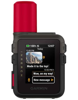
InReach Mini 2 Red
GPS communication and navigation system -


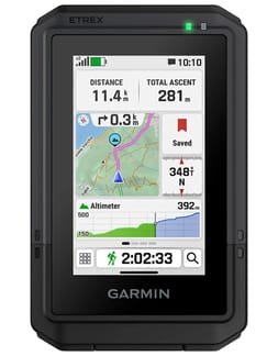


Gpsmap 65s
Outdoor GPS -


Looking for the ideal companion to keep your adventures safe and make the most of every trail? Discover Snowleader's selection of hiking GPS devices, chosen for every user from casual walkers to committed trekkers, featuring models from the leading names in navigation.
How to choose the right hiking GPS?
Every hiking enthusiast, whether beginner or experienced, knows how easy it is to lose your way on an outing. Sudden fog on a ridge, a path hidden by fresh snow, or faded waymarks: there are plenty of situations where geolocation becomes invaluable. To make the right choice, consider your actual activity, the duration of your outings, and the conditions you most often encounter.
Key criteria for a high-performance GPS
Before deciding, take time to assess the technical features that will truly make a difference on the trail:
- Battery life: expect at least 15 to 20 hours for a day hike, and several dozen hours for long-distance treks or crossings.
- Positioning accuracy: models compatible with multiple satellite constellations (GPS, GLONASS, Galileo) maintain a reliable signal even in deep valleys, dense forests, or near cliffs.
- Mapping: choose devices with preloaded or downloadable topographic maps, ideally to the IGN standard or equivalent for your region.
- Durability: a minimum IPX7 rating ensures sufficient waterproofing against heavy rain, splashes during river crossings, or accidental drops.
- Screen: good readability in bright sunlight, glove compatibility, and transflective displays are details that make all the difference in tough conditions.
- Weight and ergonomics: not to be underestimated on long routes, where every gram counts and handling must remain intuitive, even when tired.
- Price: expect to pay 150 to 300€ for entry or mid-range models, 400 to 700€ for expert versions, sometimes with sets including detailed maps or extra accessories.
GPS watch or handheld GPS: which to choose for your needs?
The GPS watch appeals to versatile users who alternate between trail running, ski touring, cycling, and mountain outings. Always on your wrist, it supports both activity and daily life, includes full physiological tracking (heart rate, sleep, recovery), and connects to a rich app ecosystem. However, its smaller screen limits comfort on long navigations, and its battery life is generally less than a dedicated handheld. For more, see our dedicated outdoor watches selection.
The handheld GPS is aimed at hikers who put navigation at the heart of their kit. Its large screen offers especially comfortable map reading, its battery lasts several days, and its rugged build is designed for the harshest conditions. It's the reference tool for long-distance trekking, mountaineering, or remote expeditions where reliability is more important than versatility.
Key features of hiking GPS devices
The hiking GPS is undoubtedly the essential companion for today's hiker. This fantastic little device, easy to carry and highly effective, helps you find your way effortlessly and avoid many mishaps.
Advanced navigation and mapping
Modern models rival professional tools for navigation. Detailed topographic base maps, customisable route plotting, track recording, points of interest, barometric altimeter, and electronic compass let you approach every outing with confidence. Expert ranges from Garmin, such as the GPSMAP or Montana series, even add 3D topographic maps, real-time weather forecasts, and satellite messaging via the inReach range, designed to keep you connected far from any network. To complete your kit, a classic compass remains a valuable backup in case of electronic failure.
Battery life and device durability
Designed to withstand the mountains, modern hiking GPS devices offer battery life of several dozen hours in standard mode, or even several weeks in power-saving mode with spaced positioning. Reinforced casing, certified waterproofing, and shock resistance make them reliable tools in heavy rain, freezing cold, snow, or river crossings. For winter outings, choose models with high-performance batteries at low temperatures and screens that remain readable with gloves-two points often overlooked when buying. On multi-day expeditions, a solar charger is the perfect addition to extend battery life without relying on mains power.
Leading outdoor GPS brands
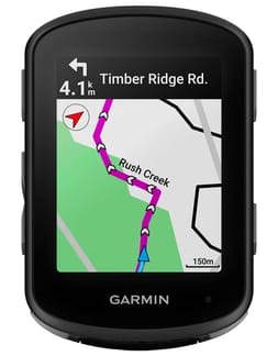
At Snowleader, as outdoor sports and leisure specialists, we work with the top brands in navigation. Our catalogue brings together the key players shaping the outdoor navigation market. Garmin has long been the sector leader, with a complete ecosystem across several ranges: the eTrex series for accessible, reliable entry, GPSMAP for experienced users seeking precise navigation, Montana for the most demanding expeditions, and inReach for two-way satellite communication. Apik complements this with the KIP beacon, a location and alert device designed as an extra safety measure for remote outings.
That's why we've specially selected a wide range of hiking GPS devices from the most prestigious manufacturers! Whatever your needs, the type of hiking you plan (on foot, in the mountains, in the forest), and your budget, we'll help you find the ideal equipment so you can enjoy your favourite activity in the best possible conditions.
Stop wasting time deciphering complicated maps or relying only on a compass-step into the modern age! Explore our full range of navigation instruments and find the GPS that will be your faithful companion, from your next Tour du Mont Blanc to a last-minute Sunday morning adventure.
GPS apps to complement your equipment
Alongside dedicated devices, mobile apps have become a major part of planning and tracking outings. They let you plot routes in advance, share tracks with the community, and keep a backup solution on your smartphone-provided you're aware of their limitations.
The best apps for safe hiking
A few standouts lead the way. Visorando is a go-to for finding routes across France, with a database of trails shared by an active hiking community. Iphigénie remains the French reference for accessing official IGN maps at 1:25,000 scale. Komoot is popular for its detailed planning and premium subscription unlocking full mapping. AllTrails, meanwhile, brings together an international community, especially useful when travelling abroad. However, beware: limited battery, lack of signal, sensitivity to cold, and mechanical fragility can quickly turn a smartphone into a paperweight at altitude. For demanding outings, a dedicated GPS remains the safest solution.
FAQ: Your questions about hiking GPS devices
How do I maintain and extend the life of my hiking GPS?
Regular maintenance significantly extends your device's lifespan. After muddy or wet outings, clean the unit with a soft, slightly damp cloth, avoiding abrasive products or solvents that could damage waterproof seals. Store the device in a dry, temperate place, and remove batteries if you won't use it for several weeks. Also, regularly update the firmware and maps via the manufacturer's software: these updates fix bugs, improve accuracy, and enhance mapping. Finally, avoid repeated full discharges on lithium batteries, as this reduces their effective lifespan.
How do I sync my hiking GPS with my smartphone or computer?
Most models connect to your smartphone via Bluetooth using the manufacturer's dedicated app: Garmin Connect is among the most popular, centralising route transfers, outing analysis, and sharing with your sports community. For computer connection, a USB cable or web interface is usually enough to import maps or export your tracks in GPX format, the standard recognised by almost all online mapping platforms. The most advanced ecosystems also offer automatic cloud backup, making it easy to recover all your data from any device.
Which accessories should I choose to get the most from a hiking GPS?
Several accessories are worth considering to get the best from your device:
- An external battery or spare batteries, essential for multi-day outings.
- A mount (strap, wristband, handlebar mount) to keep the device in view without occupying your hands.
- A protective case to boost shock and moisture resistance during transport.
- Additional topographic maps to extend coverage for your planned routes.
- A screen protector to maintain readability against scratches and daily knocks.
How does the accuracy of a hiking GPS compare to other types of GPS?
A hiking GPS is designed to work in demanding environments where accuracy is crucial for safety: rugged terrain, dense forests, unstable weather. Unlike a car GPS designed for open roads, it receives signals from multiple satellite constellations (GPS, GLONASS, Galileo) and thus maintains a reliable signal even in valleys or under forest cover. Compared to a smartphone GPS, the difference lies in antenna sensitivity, vastly superior battery life, and true outdoor durability-where phones quickly reach their limits in cold, wet, or remote conditions.
Our Bloch' letter


